
Section J southbound: 71 miles, Elevation gain/loss +18,100/-19,130 ft. -5 1/2 days July 1-6, 2025

Day 1: 11.8 miles, +3,732/-2,084 ft. Stevens Pass to Trapp Pass
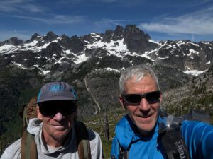
Chris drove to Seattle on July 1 and left his car at our house. Angie then drove us up to Stevens Pass on July 2 and dropped us at the PCT southbound trailhead mid-morning.
It was a beautiful morning as we started to hike up and through the forest adjacent to the Steven’s pass ski slopes. The trail stayed in the trees and we pretty easily navigated around a couple of fallen trees, several patches of snow, and water on and running down the trail. We made slow and steady progress as we gained elevation and left Stevens Pass behind.


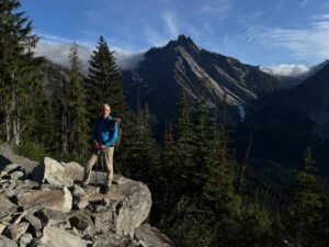
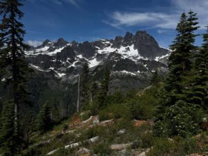
The rest of the day went well, though I neglected to take photos so I don’t have many photos from this day. We passed several nice alpine lakes (Susan Jane, Mig, Hope, and Trap) though we didn’t stay long as the mosquitoes were bothersome. We arrived at our planned stopping point of Mig lake early in the afternoon. We were still feeling good and the presence of bugs made the idea of stopping less enticing so we continued on. We kept going and eventually stopped at the top of Trap Pass which had a nice view out over Trap lake. We were tired by the time we found the small campsite at the top of the pass as we had traveled 4.5 miles further and climbed 1,600 ft. more than we planned.. It was windy at the pass as a weather front moved in so we basically pitched our tents, made dinner and went to sleep without delay as clouds rolled in and the temperature dropped. Neither of us slept well as the wind and moisture filled clouds continued through the night as we listened to trees creaking and pine needles and water drops hit our tents.
Day 2: 12.5 miles, +2546/-3686 ft. Surprise pass to unnamed creek above Hyas Lake.
The wind finally died down in the early morning hours. We woke up pretty early, ate breakfast and broke camp. We enjoyed the descent down from the pass and navigated around several trail junctions as we skirted around and above Glacier lake on the way toward Pieper Pass. We were anxious to see the conditions of Pieper Pass as it was one of two areas on this section that were reported to still be covered with snow. Well, as a result of the snow covered trail, we missed a trail junction and erroneously followed a boot track up to what we thought was Pieper Pass, but turned out to be the appropriately named Surprise Pass. Luckily there was a well maintained trail that ran down the other side of Surprise Pass and connected with the PCT at Deception Lake.


After reconnecting with the PCT and taking a short break at the pretty, but buggy Deception Lake, we continued on through Deception Pass to the most significant river ford on this section. We hadn’t seen many people on the trail to this point, but the few we had seen shared that the best place to cross was slightly down river from where the trail met the river, which split into two and required two separate fords. It took a little scouting but we found a couple of good places to cross, changed into our water shoes and made it across without any problem.

We finished day two with another mile or so to a pretty campsite adjacent to an unnamed river.

Day 2: Stampede Pass to south of Tacoma Pass. 17.4 miles Total assent 4,742 ft. Total descent 3,639 ft.
I woke up with daylight around 5:00 am. It took me an hour and fifteen minutes to break camp and have breakfast so I was walking by 6:15 am. I started the day feeling pretty well, but after a couple hours of walking I started to feel tired and had a bit of an upset stomach. Luckily that didn’t last long and I was soon feeling fine again. This seemed to be a fairly regular occurrence where it took me an hour or two to fully wake up in the morning and hit my stride. It also helped to eat something every couple of hours to keep my energy levels up. I had seen three southbound PCT hikers yesterday an was passed by 6 more PCT south bound (SOBO) hikers today. They had started at the Canadian border at the end of June or very early July and experienced a lot of snow on the trail the for the first week or two as well as unusually warm temperatures. I would cross paths with them several times over the coming two weeks. I have not seen any north bound through hikers yet. I crossed Tacoma Pass around mid day and made it to a stream which was the last water for a twelve mile stretch. I was too tired to cover the 12 miles and 2,000 feet of elevation gain in what was left of the day, so loaded up with 4 liters of water and made it to a campsite that was 5 miles and 800 feet in elevation gain. It was only 3:45 pm, but I had already done a lot of climbing and I was too tired to go any further so I made camp for the day. The campsite had room for several tents, though none of the sites for tents were perfectly flat. At about 8:00 pm, two other people arrived and quickly set up their tents. They were pretty quiet and quick setting up their tents, and I soon heard the person closest to me snoring. I could hear her moving around throughout the night. I am sure that she could also hear me move as one of the drawbacks to using an air mattress instead of a rigid foam pad is that air mattresses tend to be noisy when shifting positions.
Day 4: 14.2 miles +3,000/-2,800 ft. Waptus River to Lemah Creek
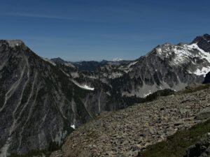
Today followed the pattern of a morning climb followed by an afternoon descent. I think we were both starting to get our trail legs so today’s climb didn’t feel as hard to me as yesterday’s even though it was quite a bit more. I particularly enjoyed the views as we gained elevation as it was nice to get out of the thick tree cover for a while.


We camped at a small campsite just across from the south fork of Lemah Creek. We put our water shoes on to cross the creek where the bridge had been washed out only to find that a tree had fallen across the creek about 40 feet downstream.

Day 5: 11.3 miles +3943/-2094 ft. Lemah Creek to below Chikamin Peak
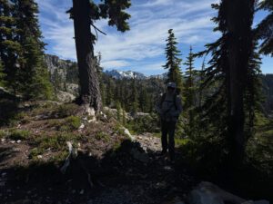
The day’s hiking took me around around several ridges, through an old burn area, down to Government Meadows and log cabin that was built by a snow mobile club, and back up another ridge and into another area that had burned years ago. It was interesting to walk through a burned forest and see just how slowly it recovers. The wildflowers seemed to be in full bloom and added splashes of color to an otherwise drab landscape, although I could never get a photo that adequately showed the wild flowers. It was very hot and dry through the second burn area as I traveled through it mid-afternoon. I camped at the end of a forested section and needed to carry water with me for several miles as the trail didn’t cross a spring until I had been hiking for several hours the next morning.


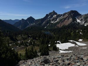


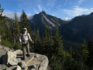
We found a nice enough campsite just off the trail below Chikamin Pass and set up our last camp of this trip.

Day 6: 9.1 miles +1,402/-3,479 ft. Chikamin peak to Snoqualmie Pass parking lot.
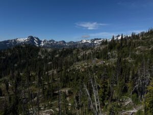
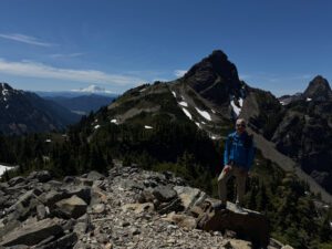
Today was another beautiful day. We had views of Mr. Rainer and Joe and Alaska lake as we crossed the last remaining patches of snow on the trail. It wasn’t long before we arrived at Ridge lake which is my usual turn around point when I day hike this section of the PCT from Snoqualmie Pass. From there, we made it across the Kendall Katwalk and Chris immediately understood that this section of the trail is like a highway compared to a lot of the mountainside trails we had previously crossed. Then it was back into the trees for the descent to the parking lot. We were done by mid morning and back home with plenty of time for me to do laundry and reprovision for the next section of this summer’s hike.


